|
weeding effort hub |
|
This page provides links on the menu above to information on recent and past weed control activities and effort, as described below. What information do we collect and Why At Friends of The Pinnacle we have always thought it important to document our weed control activity. In part this stemmed from the wish to assess our effort against the estimate in our Weed Management Plan of how many hours effort would be required to successfully control the key weed species identified at the time. After each weeding event the leader of that weeding group uses the online form to log what weeds were targeted and what methods were used, how many people took part, how long was spent and in which of our management area(s) that time was spent. Each team has at least one Garmin etrex handheld gps device that enables all weeding activities to be geolocated. The leader of the weeding group emails the track and waypoint files from each of the Garmin devices used by the team to the fotpin webmaster. The track(s) shows the areas where the weeding activity took place and the waypoint file(s) contain the locations of priority weeds that have been treated or that require follow-up treatment (such as Weeds of National Significance,Blackberries, woody weeds, etc.). What can be accessed from this page Information about what was done and where (including maps) for all weeding activities are summarised in recent weeding, accessed from the tab above, and are available there for between 1 and 2 years. For priority weed types that are predominantly controlled by spraying, maps of where treatment has been carried out are updated continuously on a seasonal basis (July to June) and can be accessed from the weeding maps link under the current season tab above. Similarly, for priority weeds that are sparser in their occurrence (African lovegrass and other Weeds of National Significance, Blackberries, Sweet briars and other woody weeds), maps of the exact locations of individual plants or patches of plants that have been treated are continuously updated and available from the weeding maps link. As well as the information appearing in recent weeding and weeding maps, the detailed effort that is logged through our online weeding effort logging form. This effort is summarised by weed type and management area and accumulated on a seasonal basis (July to June). Some examples are illustrated below. For the current season, summaries of weeding effort are updated every 3 months and are available from the current season tab above along with commentary of what the effort data is showing. The same information plus the weeding maps are available for all previous seasons from the past seasons tab above.
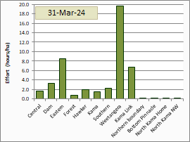
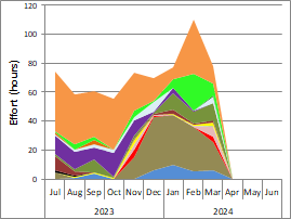
 Effort spent in each paddock (1/7/23 to 31/3/24)  Total monthly effort for different weed types
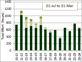
(1/7/23 to 31/3/24)  Total effort for each season
(1 July to 30 June)
|
© Friends of The Pinnacle
