In October 2014, approval was given for an extension to the Pinnacle Nature Reserve by including an area identified for an environmental offset. As an approved offset, the Pinnacle Extension will receive an enhanced level of funding for its management relative to the Reserve, as specified in a formal management plan [ 5.8 MB] is currently in place. The management plan was developed by the TAMS Offsets Group in a process that included consultation with fotpin.
What is an environmental offset?
Environmental offsets are measures to compensate for the adverse impacts of an action on the environment (generally brought about by development) that cannot be adequately reduced through avoidance or mitigation.
Offsets were established by the Australian Government's Environment Protection and Biodiversity Conservation Act 1999, as described by their Environmental Offsets Policy [ 2.3 MB], where you can find out more information about them.
The Pinnacle Offset compensates for loss of box gum woodland as a result of the development of land for the new University of Canberra Public Hospital.
Where is the Pinnacle Extension?
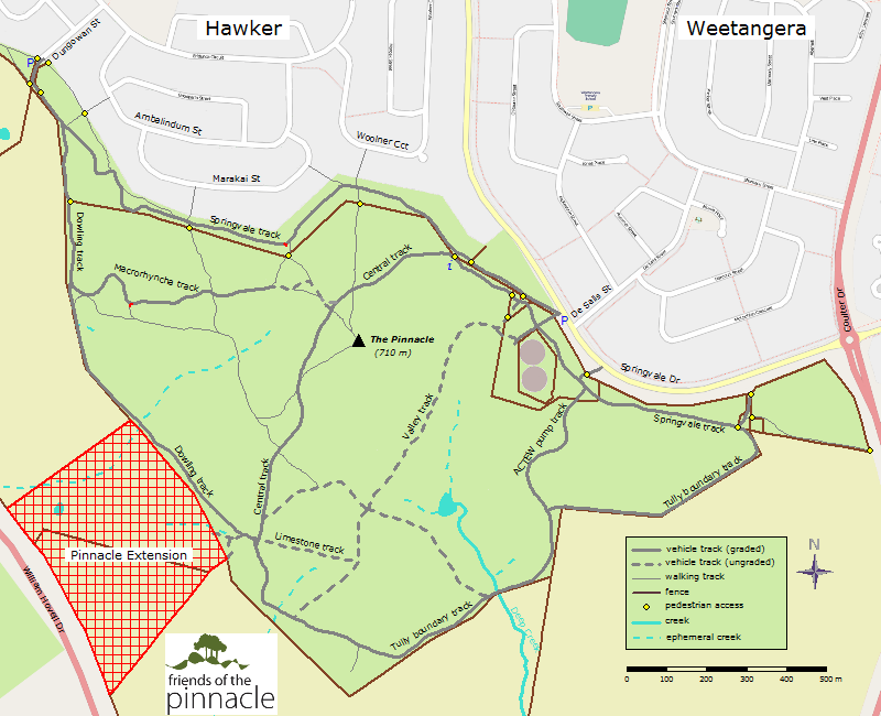
The location of the extension is indicated in red on the map below.
The extension includes the paddock that we have referred to as North Kama South and part of the North Kama Home paddock (see also a more detailed map). As can be seen in the corridor map, it provides a bridge and potential wildlife corridor between the Pinnacle and Kama Nature Reserves. It is, of course, unfortunate that William Hovell Drive disrupts the corridor and that the extension doesn't extend as far north as the underpass.
Is the Extension now part part of the Reserve?
The area has been fenced and is now officially incorporated into the Reserve. On 13 May 2016, Planning Minister Mick Gentleman announced the release for community consultation of a draft variation to the Territory Plan proposing zoning changes to incorporate the extension into the Reserve (see media release [ 188 kB]). Links to the Draft Variation and associated background documents supporting the proposal can be found below.
The rezoning is now in place and access to the Extension is considered to be the same as for other parts of the Reserve and subject to the same rules of use. It is accessible via the gate in the gully near the north-east corner (as shown by the yellow dot on the walking track map). As of mid-March 2017, this gate is unlocked but will soon be replaced by a step-through gate that will allow walkers access while still being able to be locked when grazing is required in that part of the extension to manage fuel loads in accordance with the Bushfire Management Plan.
What has been fotpin's involvement in managing the Extension area in previous years?
Friends of the Pinnacle has been carrying out weed control for at least 5 years in the area that is now the Extension. This has been for several reasons:
the northern strip of the offset has always been fenced and managed as part of the Pinnacle Nature Reserve, even though it has been officially mapped as not being part of the Reserve;
fotpin recognised the ecological values of parts of the offset area, particularly the south-east corner and sought to protect and enhance those;
some parts of the offset area close to the Reserve were (and still are to some extent) heavily infested with a range of weeds and these were treated to minimise their invasion (or re-invasion) of the adjacent parts of the Reserve; and
as time and resources permitted fotpin's weed control was able to encompass more of the adjacent land not subject to rural lease.
Is there a difference between the "offset" area and the "extension" area?
The Extension and the official Offset area do not coincide precisely. For a start, the southern fence of the Reserve does not follow the alignment specified in the Territory Plan as its official boundary, presumably for practical reasons.
A northern strip of the Offset (about 20 m wide) has therefore always been managed as part of the Reserve. In addition, when aligning the fence to define the north-west boundary of the extension, it was necessary to move it about 20 m further west to avoid running it through areas of course woody debris and rocky pink-tail worm lizard habitat.
For practical reasons, fotpin considers the Extension to be all the area enclosed by current fences that was not previously managed as part of the Reserve.
The difference between the Extension and the official Offset areas is shown in the following
pop-up map.
What has been the process leading to the Pinnacle Extension?
[Links to all documents referred to here are also summarised in the timeline below]
The Pinnacle Offset compensates for loss of box gum woodland as a result of the development of land for the new University of Canberra Public Hospital. In accordance with the Commonwealth EPBC Act (1999), when the development was proposed the site was assessed for environmental values and it was decided that one of the measures to mitigate the loss of those values resulting from development was to offset it with an area of at least comparable value. The area chosen was the Pinnacle Offset. This assessment is described in the document University of Canberra Public Hospital Preliminary Documentation EPBC Ref. 2013/6987 (April 2014) [ 1.9 MB]. At the same time, an Interim Offset Management Plan [ 0.7 MB] for the Pinnacle Offset was written.
The proposal for an offset was approved on 14 October 2014 by the Commonwealth Department of Environment (DoE): Approval documentation [ 6.4 MB].
In January 2015, fotpin received the first draft of the substantive Offset Management Plan (OMP) for the Pinnacle Offset from ACT Parks and Conservation Service (PCS) to comment on. The OMP went through a number of drafts, with fotpin input, before being forwarded to the DoE for approval in October 2015.
Comments on the Draft OMP were received back from DoE by PCS in the first quarter of 2016 and PCS revised them accordingly, seeking some input from fotpin. The final Revised Draft OMP was received by fotpin for comment in late June 2016 and comments returned on 27 June. This has now been forwarded by PCS back to DoE for final approval.
In the meantime, the section of PCS charged with implementing offset management plans commenced work on the Pinnacle Offset. Baseline surveys were completed and some weed control complementary to that of fotpins' was carried out in the first half of 2016 and fencing of the area was completed in May 2016. Ongoing discussions between PCS and fotpin have focussed on ensuring a continuation of complementary weed control and management in the Offset.
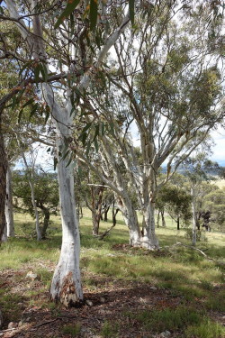
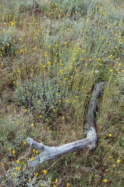
The extension is a valuable addition to the Reserve. It includes patches of endangered box-gum woodland, Eucalyptus macrorhyncha, extensive areas of native grasses and forbs and pink-tailed worm-lizard (Aprasia parapulchella) habitat. In addition it has strategic value in providing a link between the Pinnacle and Kama Nature Reserves (as can be seen in the corridor map).
Spring in the Pinnacle Extension, 2015 [photos: Carolynne Parker]
Documents relating directly to the approval and management of the Pinnacle Extension
Draft of the substantive Offset Management Plan forwarded by PCS to Commonwealth Department of Environment for comment/approval. (copy available from webmaster on request).
May 2016
Media release [ 188 kB] regarding proposed amendments to the Territory Plan to incorporate the proposed extension into the Pinnacle Nature Reserve
Draft Variation 349 [ 1.6 MB] : proposed amendments to public land overlay and zone provisions by applying a ‘Pc’ nature reserve overlay to parts of blocks 1616 and 1370 Belconnen (Pinnacle extension) and rezoning block 7 section 72 Watson (Justice Robert Hope Park) from PRZ1 Urban Open Space to NUZ3 Hills, Ridges and Buffer with a ‘Pc’ nature reserve overlay.
Revised Draft of the substantive Offset Management Plan incorporating comments by Commonwealth Department of Environment received by fotpin for comment; comments completed and forwarded to PCS on 27 June (copies available from webmaster on request).
Oct 2016
Offset Management Plan for the Pinnacle Extension finalised.