

Suggested Walks on The Pinnacle Nature Reserve
Pinnacle Nature Walk (Macrorhyncha Loop)
Starting point: end of Dungowan St, Hawker
Distance: 3.0 km return
Time:Allow 1 hour 30 minutes
Difficulty: Easy / Moderate
 Grade 3 |
Total ascent/descent: 98 m |
Description: One of the reserve’s loveliest walks, with views and varying habitats, including open grasslands and forest, and plenty of opportunities to spot wildlife. The walk follows the Macrorhyncha track through a beautiful intact section of Red Stringybark forest and more open woodland and grassland to The Pinnacle summit with its views in all directions. The return walk passes through intact box gum grassy woodland before following a management trail back to your start point.
Directions
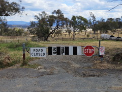
The walk starts at the boom gate at the end of Dungowan St,
just to the right of the sign describing the walks.
 |
|
| 1. |
Walk through the gap on either side of the boom gate and down the track for 50 m until you reach the "famous" Dungowan St tree - a big old hybrid Yellow Box (Eucalyptus melliodiora) that is used for nesting by several bird species in spring. Turn sharp left after the tree and step through the gate or the horse crossing (cavaletti) at the left of the gate. 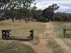
|
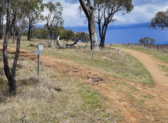
| 2. | You are now on the Dowling Track which runs alongside the western boundary of the reserve. 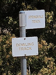
Follow it until after 100 m you reach a fork in the track and the sign post shown in the photo. While unfortunately misleading (because the sign for the Springvale Track is pointing in the wrong direction) it is useful for confirming that this is the point at which you take the right-hand track to stay on the Dowling Track running alongside the boundary fence. |
| 3. |
As you walk the 400 m to the next turn you can contrast the open forest of Eucalyptus macrorhyncha (Red stringybark) on the left with the unleased government land on the right. Aerial photographs show that this remnant patch of Eucalyptus macrorhyncha has been present since at least 1940 and we suspect for some considerable time before that. |
| 4. |
Turn left when you reach a major track junction and head steeply up the Macrorhyncha Track.
|
|
For the next 400 m the macrorhyncha forest is on both sides of you and in the right season there are native wildflowers and flowering shrubs in abundance along the sides of the track. About half way up there is an interpretative sign on your right describing what there is to see in this area of the reserve. |
|
| 5. |
As the track flattens out you cross a foot track and enter a more open woodland. Eucalyptus macrorhyncha is still present but other eucalypt species become more prevalent. Based on aerial photographs, this area is largely unchanged since 1940 but is slowly regenerating naturally, with no tree planting having taken place along this stretch. |
| 6. |
After 150 m there is a track on the left. Go past that for another 50 m to where the management trail bends around to the left and a foot track goes straight ahead. Take the foot track which will take you straight to the Central Track, whereas on the management trail after bending around to the left you need to turn sharp right to reach the Central Track. |
| 7. |
Directly on the other side of the Central Track is a foot track that will take you to the top of The Pinnacle, which is clearly visible in front of you. Head up the foot track that ends in a short steep section with steps to the Pinnacle summit. Continue slightly beyond the summit to the panorama interpretive sign that describes the features you can see in this wonderful 270 degree view. Perhaps take advantage of the nearby seat to sit and enjoy the view a little longer at the mid-point of the walk. |
| 8. | Then follow the nearby foot track leading down the southern side of The Pinnacle which after 200 m takes you back to the Central Track. 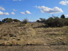
Cross the Central Track and walk up the foot track on the other side to the top of a boulder-strewn ridge. Next to the largest boulder on the right is a once-hardy Hickory wattle (Acacia implexa) growing among the boulders (now dead). After once again pausing to enjoy the views, continue down the other side of the knoll admiring the large patches of Black-anther flax lilies (Dianella revoluta). At the right time of the year you might see them flowering. |
| 9. |
At the intersection with another foot track at the bottom of the slope turn right. This will bring you to a metal walkway that makes it easier to cross what is a marshy area in wet periods. 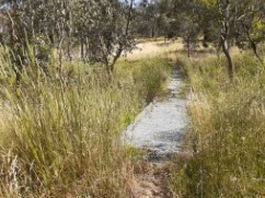
|
| 10. |
After curving around to the left the track forks; take the track leading gently uphill to the right. After 100 m you reach the intersection of this track with the Macrorhyncha Track, the intersection you crossed from the left at step 5. Cross the Macrorhyncha track and continue on the foot track until you reach the northern edge of the reserve. Turn left on the Springvale Track that follows the boundary of the reserve, with the houses of Hawker on the right, but the lovely Eucalyptus macrorhyncha forest on your left. Follow this management trail until it flattens out and emerges from the forest. From there you can see the point where you started and make your way back to it. |