

Suggested Walks on The Pinnacle Nature Reserve
Stringybark Loop
Starting point: car park opposite De Salis St, Springvale Drive
Distance: 3.7 km return
Time: Allow 1 hour 30 minutes
Difficulty: Moderate
 Grade 3 |
Total ascent/descent: 95 m |
Description: One of the reserve’s loveliest walks, with great views and varying habitats, including open grasslands, woodlands and forest, and plenty of opportunities to spot wildlife.
The walk starts by visiting The Pinnacle summit with its views in all directions, then passes through grassy woodland to the Macrorhyncha track that takes you through a beautiful remnant patch of Red Stringybark forest to the western boundary of the reserve. The return walk follows a management trail along the northern edge of the forest and the reserve boundary back to your start point.
Directions
The walk starts at the red boom gate at the western end of the car park.
 |
|
| 1. |
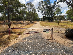
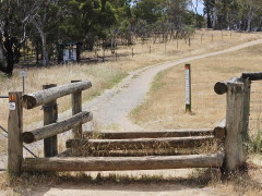
From the car park take the track through the red boom gate that runs parallel to but outside of the reserve fence. Continue straight ahead, passing a horse cavaletti on your left, and stepping through the second cavaletti you come to (shown in the photo), until you see the noticeboard on the left. Enter the reserve here then turn right to walk along the main Central Track.
 |
| 2. | After 250 m turn left onto a foot track that leads to a
short steep section with steps to the Pinnacle Summit. Continue slightly beyond the summit to the panorama sign that describes the features you can see in this wonderful 270 degree view. Perhaps take advantage of the nearby seat to sit and enjoy the view a little longer. |
| 3. | Then follow the nearby foot track leading down the southern side of The Pinnacle which after 200 m takes you back to the Central Track. 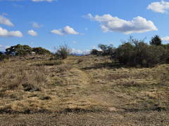
Cross the Central Track and walk up the foot track on the other side to the top of a boulder-strewn knoll. Next to the largest boulder on the right is a once-hardy Hickory wattle (Acacia implexa) growing among the boulders (now dead). After once again pausing to enjoy the views continue down the other side of the knoll, admiring the large patches of Black-anther flax lilies (Dianella revoluta). At the right time of the year you might see them flowering. |
| 4. |
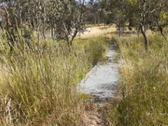 At the intersection with another foot track at
the bottom of the slope turn right. This will shortly bring you to a metal walkway that makes it
easier to cross what is a marshy area in wet periods.
At the intersection with another foot track at
the bottom of the slope turn right. This will shortly bring you to a metal walkway that makes it
easier to cross what is a marshy area in wet periods.
|
| 5. |
After curving around to the left the track forks; take the track leading gently uphill to the right. After 100 m you reach the intersection of this track with the Macrorhyncha Track. Turn left and walk down the Macrorhyncha Track, gently sloping at first but becoming steeper towards the bottom. The reserve's remnant patch of openRed Stringybark (Eucalyptus macrorhyncha) forest is on both sides of you and in the right season there are native wildflowers and flowering shrubs in abundance along the sides of the track. A little over half way down there is an interpretative sign on your left describing what there is to see in this area of the reserve. |
| 6. |
After 400 m, you reach the junction with the Dowling Track at the western boundary of the reserve. Turn right and walk along the Dowling Track which runs parallel to the boundary fence. On the right you continue to have the macrorhyncha forest, a stark contrast with the unleased government land across the fence to the left. |
| 7. |
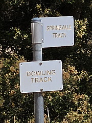
You will come to a junction in the management trails marked with an unfortunately misleading
sign post, the sign for Springvale Track pointing in the wrong direction. It is useful only
for confirming this is the point at which you turn. |
| 8. |
After a steep uphill section with a number of turns the Springvale Track then follows the boundary
of the reserve, with the houses of Hawker on the left, but the lovely Eucalyptus macrorhyncha
forest on your right. You follow this track all the way back to the carpark. |
| 9. |
After passing the noticeboard on you right and negotiating the cavaletti again you'll see the red boom gate and the carpark ahead. |